
Lake Titicaca
lake titicaca: birthplace of the sunLake Titicaca's altitude marks the start of our journey into one of the most mystical bodies of water in the Andes, a lake that graces both Peru and Bolivia with its awe-inspiring presence. Known as the “birthplace of the sun,” it is home to resilient communities such as the Uros and the Taquileños, who thrive on its unique floating islands. Scattered across its waters are ruins of ancient temples and structures that have miraculously survived centuries of history.
Where is Lake Titicaca in south america?
Lake Titicaca is located in the Andes, on the border of Peru and Bolivia, in the high Altiplano. It’s an endorheic lake, meaning it is a closed basin with little outflow to rivers or the ocean.Its western section is in Peru’s Puno region and its eastern side is in Bolivia’s La Paz Department. Approximately 60% of Lake Titicaca lies within Peru’s borders; 40% in Bolivia’s.
It comprises two sub-basins connected by the Strait of Tiquina, its narrowest point. Its subsections are the Lago Grande (Big Lake) and the Lago Pequeño (Little Lake.) Lago Grande has an average depth of 443 feet, while Lago Pequeño has an average depth of 131 feet.While little water flows out from the lake, five major rivers and approximately 20 streams feed into it. Lake Titicaca has 41 islands, some of which are populated by Quechua and Aymara-speaking cultures.

Lake Titicaca's Altitude
Sitting at an impressive 3,812 meters (12,507 feet) above sea level, Lake Titicaca holds the title of the world’s highest navigable lake. Its elevation means the air is thinner, and visitors may feel the effects of altitude during their stay. It’s a good idea to take it slow the first day, stay hydrated, and avoid heavy physical exertion until you’re acclimated. The high-altitude setting also gifts travelers with crystal-clear skies, crisp air, and breathtaking views of the surrounding Andes — a unique reward for those who make the journey.
Facts about Lake Titicaca
The name Titicaca comes from the Quechua, Titiqaqa Qucha, meaning “stone puma” or “gray puma.” It is an enormous high Andean freshwater lake. It’s also the second largest lake in South America, after Venezuela’s Lake Maracaibo. The lake is around 3820 masl and 284 meters deep at its most profound. Thought to be more than 3 million years old, Titicaca stands out for being among fewer than twenty “ancient lakes of the world.”
Titicaca is home to several unique cultures and a variety of unusual flora and fauna. The Uros People use totora reeds to build and reinforce their “floating islands,” which can, with effort, be moved. The Island of Taquile is home to a culture where the men knit and the women weave. The culture has been living in the same way for a millennium and produce all they need sans outside interference. Amantani is a third island that houses a population of communities that stick mainly to traditional Andean ways.
If you want to visit Lake Titica, visit our page "Journey to the heart of Titica" for more details.

The subtropical highland/alpine climate of this region is dry with intense sun and cool to cold temperatures throughout the year. Average highs are in the low 60s and lows in the 20s or 30s during most of the year. The region gets around 24 inches of rainfall in an average year. Lake Titicaca modulates the climate surrounding it by absorbing solar energy during the day and radiating it at night. This prevents its surrounding regions from having extremely low temperatures.
Of several species of aquatic plants that thrive in the lake, totora is undoubtedly the most useful. It is used as medicine, food, construction material for houses and boats, and a variety of handicrafts. The Uros Islands are made from, and reinforced, with totora reeds.
A variety of fauna make their home here, including 60 species of aquatic birds like grebes, ibis, flamingos, and gulls. It is a Birdlife International designated Important Bird Area. There are 26 species of freshwater snails and 18 species of amphibians, including the endangered giant Titicaca water frog. Over 530 types of fish inhabit the lake, 90% of which are endemic species.
Due to its high elevation and enormous size, the lake has a thermal regulating effect, never freezing even in the cold seasons. Because of this, the area surrounding the lake is the most important geo-economic region of the Andes. Nearly 49% of Peru’s alpacas and 32% of Peru’s sheep live here. Additionally, 29% of Peru’s llamas and 10% of its cattle are raised here.
Floating Islands of Uros
The Uros Islands were first constructed at least 500 years ago. They were built as a way to avoid the Inca that would exploit and enslave the Uros people’s ancestors. The islanders built these enormous, sturdy “rafts,” that they would inhabit to avoid contact with conquering people. These floating islands can, with effort, be relocated if necessary.
These manmade islands are constructed of reeds from the totora plant. The islanders have a multitude of uses for this plant and have completely integrated it into their way of life. Its uses range from construction, to medicine, to food. The Uros islanders have an enormous respect and affection for this giant bulrush sedge.
There are around 60 to 100 floating islands in the community. The largest is around half the size of a football field. Sizes of the islands range from 50 by 50 feet to 75 feet by 195 feet.
The totora reed base of the islands must be continually reinforced as the plants deteriorate.

The islanders also build totora reed boats that the men use for fishing and hunting. Their dwellings are made from the same material. These days, some of the homes use solar panels in a fascinating juxtaposition between ancient and modern life.
Taquile Island
Around 31 km. from Uros, we find the remote Island of Taquile, with an area of 2.21 square miles. The Taquileños, as they are known, live a communal lifestyle on their isolated island. Legends say that their ancestors departed from mainland life to form a society based on mutual cooperation.
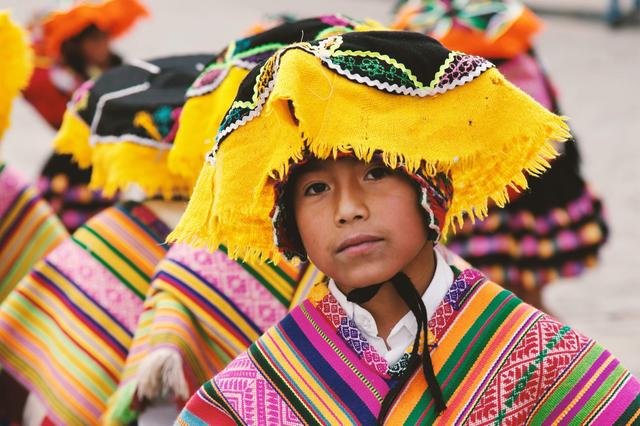
Taquile’s men participate in an ancient tradition of knitting. Boys learn to knit from a young age. A man must display his marriageability to his future father-in-law by knitting a traditional chullo, or cap. This cap must hold water without losing a drop. Each chullo is personalized for its owner. The base is threaded with intricate details about the wearer’s aspirations, hopes, and dreams. The color of the chullo also indicated the married or unmarried state of the wearer. The pompom can be worn on either side to indicate his current mood, whether joyful, sad, etc.
Women engage in spinning yarn using wooden drop spindles, and in weaving using ancient backstrap looms. Dyes are obtained from local plants and minerals. A woman about to marry weaves a chumpi, or belt from her own hair, for her fiancé to wear.
The daily rhythm of life on the island remains as it has for hundreds of years. Homestays among families on the island are possible, where visitors can experience their traditional lifestyle. A visit to Taquile Island offers a glimpse into a thriving, remote, and peaceful Andean community.

If you are interested in knowing more about the famous floating islands, visit our page "Titilaka" for an amazing experience.
Amantani Island
Amantani Island sits a short distance from Taquile, approximately 12 kilometers by boat. It has a population of around 3,500 people. The island is spherical in shape and about 3.5 square miles in size. It has two mountain peaks, Pachatata, meaning Father Earth and Pachamama, meaning Mother Earth. Both contain Tiahuanaco and Inca ruins. The Tiahuanaco people pre-dated the Inca by at least five centuries and are called the “mother culture” of South America.
Folks on the island herd sheep and raise crops like quinoa, potatoes, and wheat using the terracing agriculture technique. They are also known for their weaving and ceramics. The serene island is ideal for a homestay, where tourists may experience the homelife of a local family. Typically, visitors bring food gifts that are hard to obtain, such as rice, fruit, etc. Sugary treats are not recommended as there are no dentists on Amantani.

how to get to lake titicaca?
Arriving to Lake Titicaca is possible with a flight from Lima to Juliaca, and then an hour of ground transport (car or bus) to Puno. From Puno, depart by ferry boat to visit the lake and the islands. Alternatively, one can take the Perurail train from Cusco to Puno, with a couple of classes of travel (regular and luxury class) This journey takes around 11 hours to complete. Once in Puno, take the ferry to visit the lake and her islands.

Lake Titicaca Awaits: Peru’s Living Lake Legend
Exploring the nature, culture, and history of Lake Titicaca will is an enriching and inspiring experience. From the intriguing lifestyles of its island dwellers to its flora and fauna, Titicaca is truly a unique gem. Contact Explorandes for our help in arranging every detail of your journey to the amazing Lake Titicaca.

March - December
5 days / 4 nights

April - October
12 days / 11 nights

April - December
5 days / 4 nights

April - October
6 days / 5 nights


